

This eyewitness recollection
sparked my interest to learn more about the building of the Pine Knoll Waterway
. . . Oh yes, that couple lives today in Pine Knoll Shores.
In the 1960’s building a
canal system as part of a real estate development was a common practice up and
down the east coast. From a
governmental regulatory perspective, constructing a canal system in the late
1960s and even the marinas at Beacon’s Reach and Sea Isle in the 1980s was
significantly easier than it would be today. What with environmental
sensitivity, wetland designations, wildlife and endangered species concerns,
plant and habitat issues, water table and waste water disposal and ground water
contamination considerations, the requirement for Environmental Impact
Statements, and other county, state and federal regulations it would be a hard
slog to develop a community today with similar amenities to what we have.
 The above illustration
appeared in the July 1967 issue of Our State magazine discussing the planned
community being developed on Bogue Banks.
The above illustration
appeared in the July 1967 issue of Our State magazine discussing the planned
community being developed on Bogue Banks.
In Pine Knoll Shores the
canal system was built to address several problems and to create a number of
attractive conditions. Eliminate the negative and accentuate the positive.
The Problems: North from the dunes along the ocean, the
land was mostly low-lying. In 1998, Don Brock spoke at the town’s twenty-fifth
anniversary celebration. He recalled that when he first came here in1965, his
initial reaction was “This is just a swamp, it has to be drained.”[i]
The water table, before the canals and marinas were built was quite near the
surface. So much so, that the early houses built in the late 1950s could get
water by use of shallow wells.
The second problem that had
to be attended to, to enhance the attractiveness of the area, was mosquito
mitigation! Some early property owners considered this locale fine for a place
to come in the winter, but in the summer the mosquitoes made it intolerable.
County and state health officials were sensitive to threat posed by mosquitoes
in any low-lying, wet area, and often withheld development approval until
abatement actions were taken.[ii]
The Positives: The route of the waterway took advantage of
some existing low ponding areas; the spoils from the digging were used to fill
other low areas. An early resident, who lived on Cedar Road recalled walking cross the tidal creek that existed before the canal was built. Perhaps it looked simular to the creek pictured below which is located in the Roosevelt Natural Area.

This approach eliminated swampy swales that held water after rain and were mosquito-breading grounds. Additional spoils were utilized to raise the general level of the surrounding ground and roadways. These actions contributed to other advantageous consequence – The canals in effect lowered the ground water level improving the functioning of septic systems, it also allowed rainwater to drain without the need for roadside ditching, a common sight in low country regions.
This approach eliminated swampy swales that held water after rain and were mosquito-breading grounds. Additional spoils were utilized to raise the general level of the surrounding ground and roadways. These actions contributed to other advantageous consequence – The canals in effect lowered the ground water level improving the functioning of septic systems, it also allowed rainwater to drain without the need for roadside ditching, a common sight in low country regions.

The canals in Pine Knoll
Shores, official name Pine Knoll Waterway, were constructed in two phases. Pictured above is the east half running from McNeill Inlet to Mimosa Blvd[iii].
This phase was completed in 1967; it included Hearth’s Cove, King’s Corner arm
and Hall Haven marina. At the opening of
that phase the waterway was advertised as being 80’ wide and 8’ deep.

The second phase of the waterway was completed by 1971 and ran west from Mimosa Blvd. to Hoffman Inlet
and included Davis Landing, Hopper’s Hideaway, and Brock Basin. After the two parts of the waterway were
completed a bridge at Mimosa Blvd was constructed and the waterways two parts
were connected, thus allowing full circulation of water throughout the
waterway.
The East side of the waterway
employed a crane-mounted dragline as the primary construction approach. A crane
working from each side of the planned route of the canal would provide improved
directional control and speeded up the process. Whether one or two cranes were
used the operation would have been the same.
 |
| Typical crane mounted dragline |
In a typical cycle of excavation, the bucket is
positioned above the material to be excavated. The bucket is then lowered and
drawn so that the bucket is filled by dragging along the surface of the
material. The crane hoist then lifts the bucket. The crane is then pivoted to
move the bucket to the place where the material is to be dumped. The material
is deposited along the banks and the crane then moves forward on the mechanized
treads.
A skilled operator could throw or cast the bucket, swinging the
bucket like a pendulum. Once the bucket had passed the vertical, the hoist
cable would be released thus throwing the bucket beyond the reach of the crane
boom. Even though a cofferdam was
constructed at the sound end of the channel, huge pumps removed seepage and
standing water in the channel during construction.
 |
| Dragline excavating a canal, photo curtiscy of North LaFourche Levee District |
 |
| The State magazine, 1969 |
The canal bottom filling with sand, that migrates from the sides
soon became a serious problem. By the early 1970s a system-wide vertical bulk-heading
program was undertaken.
This dragline construction approach produced another result that
is observable today. The land adjacent to the east end canal is noticeably higher then
the otherwise natural elevation. As the dragline cranes went about their
business they produced mounds of material and high ridges that line the canal
path. In places on top of existing dunes or filling swales between dunes and in
other place running perpendicular to the natural east/east run of the
dunes.
After the East side of the waterway was completed the developers
and the Roosevelt’s were displeased with the damage this approach instilled on
the land and the nearby vegetation, particularly the mortality to both pine and
hardwood trees. A review of the condition by the School of Forestry, NC State [iv]pointed
out, “The lower water table, cuts and fills, mechanical injury, and sudden
exposure are four, any of which could place the trees under Stress.” Accordingly,
a new construction approach was employed for the West end of the waterway
system.
To avoid some of the negative impacts on the environment, AC
Davis, a local construction contractor and civil engineer suggested and
approach that employed pan scrapers and bulldozers.
 |
| Typical motorized pan scraper of the era |
Some
of the advantages with pan scrapers are improved control of the depth and
condition of the excavation and better control of the placement of the dredged
material. Using the pan scraper technique one machine does the excavating,
carrying, and leveling. As the machine traverses the excavation site it scrapes
up a thin layer of material that is held in the machines hopper, when full it
travels to the dispersal sight and deposits the material in a thin controlled even
layer. This process is repeated as often as needed to attain the desired depth.
In the case of the East end canal the material was used the fill low spots and
to build up the roadways. Thus avoiding the high unnatural mounds and
unintended damage to vegetation experienced during the East construction.

Before
the dedicated motor scraper came into regular use in the 1960s, there were
smaller versions: the towed scraper, one of the first bulk earthmoving machines
invented. Nineteenth-century scrapers were drawn by horses, but were later
adapted for use with tractors and bulldozers.
After
the two parts of the canal were completed, only a small land link on which ran Mimosa
Blvd remained as the final barrier to a free flowing continuous waterway. The
original idea was to install a culvert under the roadway to allow water to flow[v]. They
decided instead, to install a bridge to allow better tidal action circulation
and permit small boaters to pass from one side of the canal to the other. A
contract was entered into with T.D.Eure Construction Co of Morehead City in May
1972 to build such a bridge. The entire contract document is shown below.[vi]
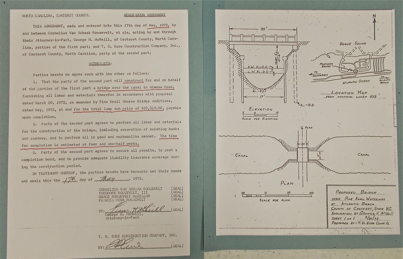
The construction schedule called for
completing the task in four and a half weeks at a cost of $20,210. (An amount similar to the cost of the bridge over the canal at Oakleaf.[vii])
As is the case with many construction projects, difficulties were encountered.
The cost remained the same, but completion took an extra two weeks. That bridge
built in 1972 was replaced in 2012, after a multi-year project, that also ran
into a few difficulties, and at a cost substantially higher.
In
addition to providing many recreational benefits, the canal system lowers the
water table, which improves the operation of everyone’s septic system, helps
drain the land, enhancing the dispersal of storm water and eliminating the need
for road-side drainage ditches. All of which contributes to keeping the
mosquito population at a tolerable level. The ownership and responsibility for
maintaining the waterway is spread among several groups. The contents of the
canal are federal/state waters, the bottom of the canal was deeded to Pine Knoll
Association by the Roosevelt family, and the bulkheads are the responsibility
of adjacent landowners as specified by town ordinance. Maintaining navigable
depth is the responsibility of PKA. In
the past PKA working in conjunction with the town, have been able to acquire state
grant moneys to partially defray the cost of needed periodic dredging. While the
natural forces that move silt to the canal continue, there is no guarantee that
state funding will be available in the future.
Contact the History Committee
[i]
Audio recording of PKS 25th anniversary, available in the archives
of the Pine Knoll Shores History Committee.
[ii]
Letter from J.W.R. Norton, M.D., State Health Director to T.F. Hearth, 18 June
1965, archives of the Pine Knoll Shores History Committee.
[iii]
Photo by Bob Simpson, as presented in Jack Dudley’s book Bogue Banks
[iv]
Letter from F.E. Whitford, Forestry, NC State University-Raleigh, 27 May 1969,
archives of the Pine Knoll Shores History Committee.
[v]Annual
meeting minutes, Pine Knoll Association.
[vi]
T.D.Eure collection in the archives of the Pine Knoll Shores History Committee.
[vii]
Henry Von Oesen & Associates Budget Estimate, Jan 26, 1966, bridge at
Oakleaf $27,500. Archives of the Pine Knoll Shores History Committee.