

The story of Pine Knoll Shores would not be
complete without a discussion of tropical storms. In fairly recent history,
meteorologists have established June 1 to November 30 as hurricane season on
the east coast. However, over the years, actual tropical events coming within
75 miles of Bogue Banks have fallen into periods of activity and periods of
inactivity. The following discussion does not include nor’easters or general
low-pressure periods that bring heavy rains, often with thunder and lightning.
It begins with a definition of terms.
In the Indian Ocean, they are
called Cyclones. In the Pacific, they are referred to as Typhoons. Here on the
shores of the Atlantic, we call them hurricanes. To a professional
meteorologist, they are all tropical cyclones.
A tropical cyclone is a warm-core, low-pressure
system producing high winds that spiral counter-clockwise (in the northern
hemisphere) and inward, with the highest winds near the center of circulation .
. . and rain bands spiraling toward the center. These warm-core storms
typically form over the tropical and subtropical oceans and extract their
energy from the heat content of the oceans.[i]
North Carolina ranks third, after Florida and
Texas, in the number of hurricane strikes since 1899 (Louisiana and North
Carolina often alternate between third and fourth). Florida has had far more hurricanes
than any other state—more than twice as many landfalls as North Carolina since 1899.[ii]
The impact of a hurricane is
a function of several conditions. Wind speed is the most commonly applied
indicator of a hurricane’s strength. Wind speed is broken into categories in
the Saffir-Simpson Scale based on the severity of the damage expected: Tropical
Depression, Tropical Storm, and five levels of hurricanes.

Saffir-Simpson Scale doesn’t
tell the whole story. Other factors come into play in determining the severity
of a storm’s impact:
Position of the storm track relative to your location
Speed of the storm along its track – forward speed
Diameter of storm
Weather preceding the storm, particularly rainfall
Tidal cycle and the associated storm surge
Slope of the sea floor, which impacts the storm surge
Storms are no longer a
surprise. The science of hurricane forecasting and public communication of
alerts are constantly improving. The National Hurricane Center (NHC) of the
National Weather Service, part of the National Oceanic and Atmospheric
Administration (NOAA), provides a database and forecasts for hurricanes
affecting the Atlantic, Pacific, and Caribbean coasts of the United States.
Additionally many other countries, some Universities, and several private
companies provide hurricane projections.
Before NHC, folklore provided
forecasts based on approaching cloud formations, sky color, and the action of
livestock. Today’s forecasts are the product of massive amounts of data entered
into complex mathematical equations (algorithms), which are then solved
thousands of times with one variable changed each time. All this is done on
super computers with data gathered from dozens of specialized weather
satellites, ocean and land based monitors, and aircraft flying directly into
storms. Each forecasting entity has developed one or more of its own algorithms
that attempt to model the impact and relationship of the multiple variables.
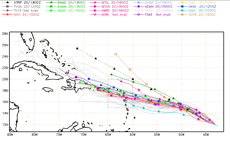
The result of all this work is depicted on what is commonly called a “spaghetti
chart.” Each line represents results from a separate forecasting model.
Coastal Carolina Historic Accounts
Peter Carteret, who served as
governor from 1670 to 1672, reported that in 1667 a hurricane destroyed both
corn and tobacco crops and blew down roofs. In 1668, first drought and then
torrential rains ruined crops. Another hurricane struck in 1669, which,
according to Carteret, destroyed what tobacco was out and most of the corn. The
following year, a 24- hour hurricane blew down trees, houses and barns.[iii]
Long-time resident Neal
Willis shares her memory of storms:
The
storm of 1933 was unexpected and did extensive damage in Beaufort, Merrimon and
South River. Hazel, the first major hurricane since the 1933 event, hit in
October 1954 [with] no real warning. [F]lags were raise[d] on towers in
Morehead and Beaufort indicating different storm conditions. The telegraph
office would post daily weather bulletins on their windows. I don’t remember
radio stations broadcasting weather bulletins.[iv]
History of Hurricanes on Bogue Banks
An extensive historical data
collection is available on the NOAA website.[v]
It permits the user to view the historical material from 1842 through 2014 in many
different ways. Using that source, I’ve created the following charts with a
focus on Pine Knoll Shores.

The above chart shows the
tracts of all the tropical cyclone events or tropical depressions through Category
5 in the Atlantic basin during the past 173 years. The total storms depicted
number 1,654, most originating as a depression off the west coast of Africa.
The figure below shows only
those tropical storms that passed within 75 miles of our town.

During the past 173 years,
102 storms have come within 75 miles of PKS.

The above chart eliminates
tropical depressions and tropical storms with winds less than 73 mph, leaving
42 Category 1 through Category 5 storms. Of the 1,654 storms that rolled off
the west coast of Africa, only 2.5 percent resulted in a hurricane that came
within 75 mile of Pine Knoll Shores. Within that circle there are NO Category 5
storms and only one Category 4—Helene in 1958, which passed 25 miles to the
southeast.

The above chart shows the 17
storms that came within 25 miles of PKS. The color of some of the tracks change,
indicating the strength of the storm decreased as it moved by.
The eye of one storm passed
directly over Pine Knoll Shores! That was a Category 1 event that passed over
the island on August 23, 1918. In Alice Hoffman’s unpublished autobiography,
she mentions severe weather the summer after she purchased her property on the
banks. She does not always get her dates exactly right, but lists, “…the
hurricane in the summer of 1917, the blizzard that year at Christmas, & the
terrific thunderstorm the previous year.”
Other hurricanes that crossed
Bogue Banks are as follows:
Unnamed – August 18, 1879, Cat 2
Unnamed – July 31, 1901, Cat 1
Ione – September 19, 1955, Cat 1
Donna – September 12, 1960, Cat 2
Ginger – October 1, 1971, Cat 1
The period from 1987 through
1995 was quiet with no storms impacting Bogue Banks. The last half of the 1990s
was the most active period:
Bertha – July 1996 — Cat 2 passed 60 miles to the west with 90 mph winds
Fran – September 1996, Cat 3 passed over Cape Fear with 100 mph winds
Josephine – October 1996, TD passed 60 miles to the NW with 45
mph winds
Bonnie – August 1998, Cat 2 passed 30 miles to WNW with winds of 85 mph
Dennis – August 1999, Cat 2 passed 95 miles to the S with 90
mph winds
Floyd – September 1999, Cat 3 passed 40 miles to the NW with 105 mph winds
Isabel – September 2003, Cat 2 passed 45 miles to the ENE with 95 mph winds,
Alex – August 2004, Cat 2 passed 50 miles to SE with 85 mph winds
Ophelia – September 2005, Cat 1 passed 45 miles to the SSE
with 45 mph winds
Irene – August 2011, Cat 1 passed 15 miles to the East with 75 mph winds
Arthur – July 2014, Cat 1 passed 15 miles to the East with 75 mph winds
Tropical Storms

This chart removes all the
hurricanes H1-H5 and presents the tracks of the 20 Tropical Storms (TS – 39 to
73 mph) that crossed the 25-mile circle during the 173-year period. The events
during recent times, since storms have been given names, are listed below:
1964 – Dora, August
31
1971 – Doria, August
27 direct path over Pine Knoll Shores
1981 – Dennis, August
20
1985 – Kate, November 22
1996
– Josephine, October 1996 (After Hurricanes Bertha and Fran, so caused lots of
problems.)
1999 – Dennis, August 20
2007
– Gabrielle, September 9
Patterns, though
unpredictable, are historically evident. The first home was sold in what is now
Pine Knoll Shores in 1958, the year of Hurricane Helene. The decade of the 60s
was relatively quiet, with only two named storms within 75 miles, one Category
2 hurricane and one much smaller tropical event. In the next two decades, there
were no hurricanes and only two tropical storms. The mid-90s began a period of
considerably more activity, with a series of severe storms. After Isabel in
2003, the named storms that have come close to Pine Knoll Shores through 2015
have been fewer and much less severe.
Time Distribution

For the past 173 years, the
peak of the Pine Knoll Shores hurricane season has fallen between mid August
and mid-September. The earliest date for a storm was May 29, 1908, a Category 1
event that passed 35 miles to the southeast. The latest occurred on November 2,
1861, a Category 1 storm that passed 15 miles to the north.
Summary and Mitigating Factors
Pine Knoll Shores has clear
exposure to potential hurricane damage. The beach to the south faces directly
on the Atlantic Ocean. The shore on the north borders Bogue Sound. However, this
part of Bogue Banks also has a few natural factors that help to mitigate the
potential damage. Protection is offered by natural geographic/geological landforms
and native flora. With s southern exposure to the Atlantic, Bogue Banks is
geographically more protected than northern Outer Banks, which juts far into
the Atlantic.
The first line of defense
along the oceanfront is the natural line of dunes. In most places, the dunes
offer high ground and are backed by ridgelines of past frontal dunes. These
dunes prevent over-wash during storm surges, as has happened in the past on
Bogue Banks, both to the east and west of Pine Knoll Shores. During the 1996
hurricane season PKS was visited by Bertha, Fran, and tropical storm Josephine,
and as a result, lost significant dune frontage, in places up to 20 or 30 feet.
Undermining and structural damage was sustained at a number of buildings and
beach access stairs. The Iron Steamer Pier lost about 100 feet.
On the oceanfront, sea oats
and fences help build the dune back toward where they are held in place by a
jumble of vegetative growth called the dune thicket. These thickets, that in
their undisturbed condition are nearly impenetrable, slow the wind velocity,
which causes wind-borne sand to fall out and further build the dune structure.
The thickets are composed of various types of trees, scrubs, grasses, and
vines, the roots of which lock the sand in-place and help prevent wind and
water erosion.
 |
| Pine Knoll Shores 2015 |
The other element that
mitigates a storm’s impact here is the geology of the island—sand. Heavy rains
typically accompany tropical cyclones regardless of the underlying wind
strength of the storm. The depth of sand that makes up the banks allows rapid
draining of rain accumulation, lessening the impact of flooding and runoff
erosion that is so destructive on the mainland.
Hurricanes are a part of
living anywhere on the east coast of the US. Taking precautions and getting
prepared when a storm is in the forecast are always wise steps. Each
individual’s circumstances will dictate the form and extent of that preparation[vi].
In addition to preparing for a specific event, a long-term strategy is also
needed. The natural elements, dunes, dune thickets, and the maritime forests,
which protect and renew the island, are critical for its survival and our
continued ability to live here safely and enjoy our home.
Post Author: Walt
Zaenker
To contact the author
or the History Committee email